Submitted by Berrin Chatzi Chousein
Project:Lusatian Lakeland landmark
Turkey Architecture News - Jul 02, 2014 - 18:45 16162 views
© Udo Meinel, Berlin
Between Dresden and Berlin, the largest artificial lake landscape in Europe is emerging. Lusatia’s lignite fields are becoming the Lusatian Lake Land. The mighty craters left behind where huge diggers once lifted lignite out of the earth are now being flooded. A former moonscape is being trans-
formed into a »water world« of thirty lakes, ten of which are connected by navigable canals. Right in the centre is the »Lusatian Lake Land Landmark«, an unmistakeable symbol of the future that provides a panoramic view of the lake landscape. its lake and becoming a Lake Town
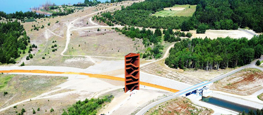
Image:IBA
Mining has shaped the Lusatian landscape for about 150 years. In the nineteen-fifties, the GDR decided on a self-sufficient energy policy to prevent dependence on coal and gas imports. The only way to achieve this was to systematically exploit lignite resources – the republic’s only significant energy source. Over 100 small towns, villages and housing developments were sacrificed to mining. As many as thirty open-cast trenches were being worked simultaneously, turning a centuries-old cultural landscape into a moonscape. Unlike hard coal, lignite generally lies just forty to sixty metres below the surface, making it relatively easy to mine it using the open-cast method.
The triangle of land containing Grossräschen, Senftenberg, and Hoyerswerda was particularly rich in lignite; so many open-cast mines were opened up here and in many places only a thin strip of land separated the individual trenches. Some of the trenches were exhausted before the reunification in 1990, and all the mines in the region were shut down subsequent to it. They were cleaned up, recultivated, and flooded. Ten lakes are presently either flooding or already full in the »triangle« alone, while the Lake Senftenberg has existed since the nineteen-seventies.
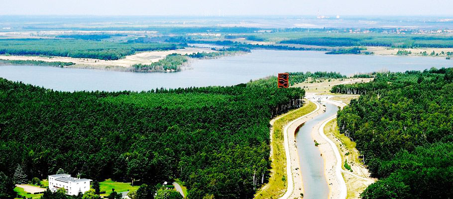
Image:IBA
Not counting the Lake Senftenberg, nine further lakes are presently being created in the Grossräschen-Senftenberg-Hoyerswerda region – including the Lake Großräschen, the Lake Sedlitz, and the Lake Geierswalde. Because these ten lakes are so close together, they present a special opportunity for tourism – they are the heart of the Lusatian Lake Land. The narrow strips of land left between the old trenches have been »perforated« to create canals between the new lakes. In a few years, canoeists and sailors will have at their disposal an expanse of water 7,000 hectares wide, stretching from the Lake Senftenberg in the west to the Lake Spreetal in the east with the Lake Sedlitz in the middle. To this navigable lake network will be added around a dozen more lakes, from the Lake Bärwald at Boxberg to the Lake Bergheide near the F60 Visitors’ Mine. Once the flooding has been completed, the Lusatian Lake Land will cover around 14,000 hectares.
It will be not only the biggest artificial lake district in Europe but the biggest lake district, artificial or otherwise, in Germany – and it is already bigger than the Müritz Lake District. But the Lusatian Lake Land will be more than a »second-rate Mecklenburg Lake District.« These lakes were created by human hand, and the IBA has no wish to pretend otherwise. What sets the Lusatian Lake Land – and the region as a whole – apart, is the tension between industrial and natural influences. Despite 150 years of mining, sweeping industrialisation and an influx of ten thousand workers, the region has always retained a certain rural identity. Here, the historic Spreewald cultural landscape collides with uniform conifer plantations, and old cultural landscapes combine with meadows and fruit trees on the sandy deserts left by lignite mining. Isolated power plants and factories – monuments to industry – are dotted, seemingly randomly, around the landscape.
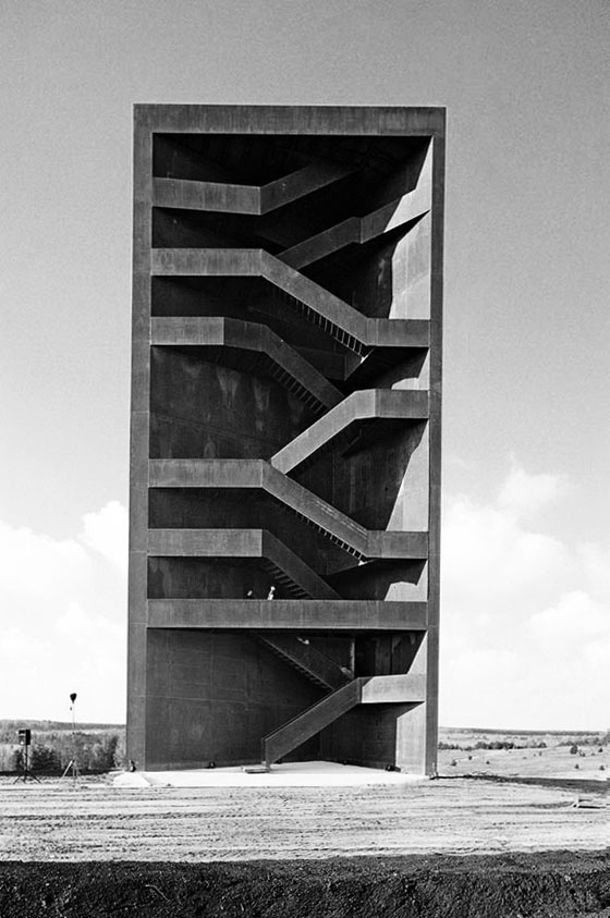
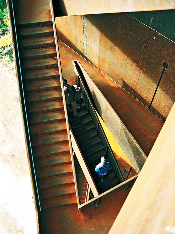
And this stark contrast between nature and industry is reflected in the Lusatian Lake Land. Rather than smoothing out this tension, the IBA wanted to highlight it. Needing a tangible symbol, they finally joined forces with the city of Senftenberg in 2005 to hold an architecture competition to design a »Lusatian Lake Land Landmark«: a viewing tower on the Sorno canal between the Lake Sedlitz and the Lake Geierswalde (and between Brandenburg and Saxony) in the heart of the Lake Land, which would also be a sculpture and a symbol for the transformation of the landscape. Out of 145 entries, the partnership Stefan Giers from Munich and the landscape architecture firm Giers from Wettenberg won. In 2008, the LMBV (the sponsor of the project), the city (contractor for the project), and the IBA (project initiator), celebrated its opening together – appropriately enough, in a year with the IBA theme Seensucht Lausitz (a play on See= lake and Sehnsucht= longing. Made from rust-coloured Corten steel, the Landmark is intentionally reminiscent of the industrial origins and history of the Lake Land and of steel mining machinery – while the sculptural staircase is a symbol of human achievement and of the future. From a height of thirty metres, its users can see three lakes and the Schwarze Pumpe, Boxberg and Jänschwalde power plants on the horizon.
Since its opening, the Landmark has received widespread attention in specialist circles, among the general population, and from visitors. The project has received architecture prizes and positive reviews in specialist magazines, as well as high visitor numbers. The Landmark has also become a popular destination or stopping-off point for cyclists and roller-skaters, and has been nicknamed the »Rostiger Nagel» or rusty nail.
© Stefan Giers, München


> via IBA,Pinterest,detail-online.com