1. EXECUTIVE & STRATEGIC PROJECT FRAMEWORK
1.1 Project Vision, Location & Strategic Positioning
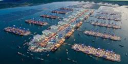
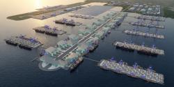
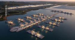
Project Vision: The Proposed Cagayan Automated Deep Seaport is intended to serve as the premier eco-friendly, high-capacity maritime gateway of Northern Luzon. By utilizing a zero-reclamation offshore piled platform layout, the project sets a new global benchmark for climate-resilient, environmentally compliant maritime infrastructure. Its core purpose is to provide next-generation international connectivity across global cargo supply networks, heavy industry manufacturing distribution, bulk commodities trade, and modern automated logistics systems.
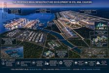
Strategic Location & Positioning: Situated inside the Casambalangan Corridor of Santa Ana, Cagayan, the site provides unparalleled direct proximity to multi-billion dollar international trade zones and deep-water ocean pathways. It establishes an efficient multimodal sea-air nexus with the proposed Cagayan International Airport and the Cagayan Economic Zone Authority (CEZA) freeport framework via an integrated infrastructure spine.
1.2 Strategic Role Within the Sta. Ana Mega Hub
The Seaport serves as the central logistics node of the proposed mega-development, feeding international cargo networks and specialized raw material requirements directly into every industrial layer. The overall strategic ecosystem operates as an unbroken, automated trade and resource loop:
[OFFSHORE DEEP-SEA PILED PORT / INLAND LOGISTICS ZONE] -> [BRICS INTERNATIONAL UNIVERSITY] -> [CAGAYAN SMART HOSPITAL] -> [CNSERIEP ENERGY PARK] -> [CAGAYAN INTERNATIONAL AIRPORT] -> [CEZA / PORT IRENE]
Together, these components form the proposed AI-Driven Industrial, Logistics, Energy, Health & Education Mega Hub.
2. FACILITIES & TECHNICAL DEVELOPMENT
2.1 Offshore Piled Platform & Inland Master Configuration
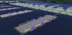
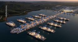
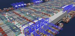
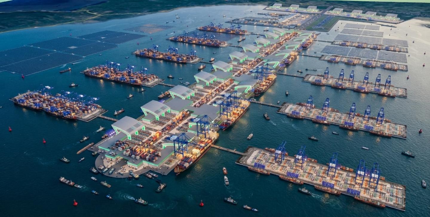
The infrastructure engineering completely decouples the seaport into two distinct functional layers. The offshore component avoids traditional dredging/reclamation damage by using highly stable structural marine piles driven directly into deep water. This platform hosts the Automated Quay Cranes (AQCs), Automated Stacking Cranes (ASCs), and Automated Guided Vehicles (AGVs) navigating on a synchronized digital grid. The inland component acts as a high-density, secure customs-bonded trade zone executing e-commerce processing, cold-chain agricultural storage, and value-added manufacturing across an onshore land envelope of 600 hectares.
DEVELOPMENT BLOCK / PLATFORM PRIMARY LOGISTICAL FUNCTION
Marine Berth & Offshore Quay Interface Deep-water vessel berthing, automated quay cranes (AQCs), and zero-reclamation piled access lines (Offshore platform).
Offshore Automated Stacking Yards Robotic stacking cranes (ASCs), AGV navigation tracks, and real-time container tracking on structural decks.
Inland Smart Warehousing Complex Customs inspection nodes, high-density automated storage, and e-commerce sorting hubs (600 Ha Inland Zone).
Export Manufacturing Park Value-added manufacturing, light assembly lines, and direct bonded access to the offshore terminal (600 Ha Inland Zone).
Inland Container Depot & Gateways Optical container recognition, digital truck appointment handling, and heavy intermodal rail integration.
2.2 Core Technical and Systems Integration
The project brief establishes a primary long-term framework to enforce high-efficiency connectivity. Key technical focus areas include:
- Offshore Automation: Automated Quay Cranes (AQCs) and automated vessel berthing management networks operating on the offshore deck driven by centralized optimization algorithms.
- Intermodal Transit Spine: An enclosed, high-capacity transportation spine connecting the offshore berths directly to the inland depot and the adjacent proposed airport cargo terminal.
- Inland Industrial Processing: Advanced manufacturing zone footprints equipped with smart utility loops and direct customs clearance.
- Climate-Resilient Piling: Comprehensive marine engineering featuring deep-sea structural piles designed to withstand extreme tectonic actions, typhoon wave forces, and severe storm surges.
2.3 Modular Phasing and Ultimate Capacity
The project is engineered for modular, scalable build-outs up to an ultimate capacity of 100 Million TEUs per year. This figure represents the long-term master-plan potential, rather than the initial operating capacity. Development is structured into five distinct phases:
- Phase 1: Initial international container terminal offshore piled infrastructure and the core 600-hectare inland logistics park construction.
- Phase 2: Additional offshore container berths and expansion of automated stacking yards on deep-sea piles.
- Phase 3: Expansion into multipurpose and industrial cargo platforms offshore.
- Phase 4: Additional international offshore container terminal modules to scale throughput.
- Phase 5: Ultimate expansion toward the master-planned capacity of 100 Million TEUs per year.
2.4 Design, Systems & Connectivity Cost Considerations
The seaport concept will strictly implement the cohesive architectural design language established by Architect Hermenegildo C. Mercado, UAP. The modern automated quays, high-volume structural warehousing arches, and integrated ground transfer hubs are defined by iconic functional layout configurations. These design profiles serve as a primary aesthetic and functional anchor, allowing the integration of clean renewable energy matrices and advanced safety systems directly into the infrastructure skin.
The complex will incorporate smart maritime and digital systems designed to improve logistics delivery, operational efficiency, perimeter security, energy management, and data-analytics capabilities:
- IoT-connected container tracking and automated high-density warehousing systems;
- Digital twin operations system for complete real-time port monitoring and predictive yard maintenance;
- AI-enabled container flow tracking and crane asset utilization analytics;
- Unified port enterprise resource software, secure cloud structures, and cyber defense grids;
- High-capacity telemetry data links and marine traffic radar processing systems;
- Smart access biometric barriers and perimeter electronic surveillance networks;
- High-efficiency terminal climate control plants and localized intelligent LED lighting grids;
- Solar photovoltaic arrays and industrial Battery Energy Storage System (BESS) microgrids;
- Stormwater harvesting infrastructure, greywater reuse loops, and automated port waste management.
2.5. Proposed Maritime Configuration
The conceptual seaport will be designed around a deep-water navigation system capable of accommodating large international container vessels. The final channel and berth dimensions shall be determined by: vessel design specifications, existing water depth, required under-keel clearance, tidal conditions, sedimentation, wave conditions, navigational safety, and turning-basin requirements.
The conceptual development provides a robust Container Terminal featuring multiple deep-water container berths, automated quay cranes, automated stacking cranes, automated guided vehicles, electric terminal tractors, and high-capacity container yards on structural decks. A Multipurpose Terminal handles general cargo, project cargo, breakbulk, agricultural commodities, and industrial equipment.
2.6 Proposed LNG and Energy Berths
The port will include dedicated marine infrastructure to support the proposed CNSERIEP, including an LNG carrier berth, petroleum tanker berth, LPG carrier berth, crude-oil unloading berth, product tanker berth, and emergency marine-response facilities. The port-side scope covers marine berth structures, navigation, mooring, marine loading/unloading systems, marine transfer interfaces, metering, and safety systems. To avoid double counting, strategic onshore fuel/LNG storage tanks remain separately budgeted under the CNSERIEP project and are excluded from the seaport CAPEX boundaries.
2.7 Automated Container Terminal
The proposed container terminal is designed as a highly automated logistics platform utilizing automated quay cranes, automated stacking cranes, automated guided vehicles, optical container recognition, RFID and digital cargo identification, AI yard optimization, automated gate systems, digital truck appointment systems, container tracking, electronic documentation, and real-time vessel scheduling. The objective is to minimize vessel turnaround time, truck waiting time, container handling costs, yard congestion, and human-error risks.
2.8 AI-Driven Smart Port System & Port Digital Twin
Artificial intelligence will be integrated into the port's operational management to handle vessel arrival forecasting, berth allocation, container yard optimization, crane scheduling, truck dispatching, cargo movement, equipment maintenance, energy consumption, security monitoring, weather monitoring, typhoon preparedness, and predictive maintenance. A centralized Port Digital Twin will provide management with a real-time virtual representation of the entire port's offshore and inland networks.
2.9 Renewable Energy, Port Electrification & Climate Resilience Design
The project will pursue a low-carbon, net-zero port operating model incorporating Solar PV, industrial BESS, electric RTGs, electric forklifts, electric terminal tractors, electric service vehicles, shore power, smart energy-management systems, LED intelligent lighting, and AI energy optimization. Because Cagayan is exposed to major tropical weather systems, the final design incorporates strict climate resilience. Engineering studies will address typhoon winds, storm surge, extreme rainfall, coastal flooding, wave action, earthquake hazards, liquefaction, tsunami risk, sea-level rise, and sedimentation. The location and orientation of breakwaters, berths, and piling infrastructure shall be determined through professional coastal and marine engineering studies.
2.10 Comprehensive Port Security Architecture
The project will incorporate a comprehensive security architecture including CCTV, AI video analytics, automated access control, container scanning, radiation detection, drone monitoring, vessel monitoring, cybersecurity systems, perimeter security, a port command center, and emergency response facilities. The objective is to create a secure international maritime gateway consistent with applicable Philippine and international port-security requirements.
2026
Project Identification & Investment Snapshot
The underlying Smart Port operating model identifies annual marine and yard personnel payroll, offshore infrastructure maintenance, advanced security monitoring, automated container yard software licensing, terminal energy draws, and deep-sea piling structural integrity monitoring as major components of seaport OPEX. The reconfigured 1,500-hectare footprint provides an optimized, hyper-efficient structural layout split into a 900-hectare deep-water offshore container terminal and a 600-hectare inland industrial processing park. The total US$10.0 Billion development CAPEX accounts for the comprehensive construction envelope, automated marine equipment arrays, and inland land acquisition to ensure complete fiscal transparency.
ITEM PROJECT BASIS
Project Name Proposed Cagayan Automated Deep Seaport
Project Positioning Deep-sea piling offshore maritime gateway, global container transshipment hub, and master-planned inland industrial aerotropolis zone
Development Context Part of the Proposed Mega Infrastructure Development in Sta. Ana, Cagayan
Location Casambalangan–Port Irene, Santa Ana, Cagayan, Philippines
Total Project Footprint 1,500.0 Hectares total (9,000,000 sqm Offshore / 6,000,000 sqm Inland)
Offshore Engineering Model No Land Reclamation. 900-Hectare platform supported by deep-sea structural piling
Inland Component 600-Hectare industrial park, smart logistics zones, and export processing areas
Gross Floor Area Approximately 450,000 sqm (Inland Logistics Districts, Customs Gates & Terminal Complexes)
Handling Capacity Conceptually supporting up to 100 Million TEUs per year ultimate master-plan build-out capacity
Employment Generation Direct employment generator for 100,000 direct and 250,000 indirect regional positions
Personnel / Crew Approximately 15,000 total administrative, technical, safety and automated yard operators at stabilized scale
Development CAPEX, excl. land US$9,758,064,516.13 / ₱605,000,000,000.00
Land Acquisition Cost ₱15,000,000,000.00 / approx. US$241,935,483.87 (Strictly for the 600 Ha inland footprint, included inside CAPEX cap)
Total Investment incl. land US$10,000,000,000.00 (Strictly US$10.0 Billion Line Target / ₱620,000,000,000.00)
Reference Annual OPEX US$750,000,000.00 / ₱46,500,000,000.00 per year
Planning FX / Designer ₱62.00 = US$1.00 / Architect Hermenegildo C. Mercado, UAP
Executive Summary & Investment Core
The Proposed Cagayan Automated Deep Seaport is envisioned as a world-class, AI-driven maritime mega-hub forming the core logistics and transport anchor of the Proposed Mega Infrastructure Development in Sta. Ana, Cagayan. The facility is planned to be seamlessly integrated with automated industrial and intermodal networks, creating a highly efficient international transit and trade ecosystem. The Seaport will occupy approximately 1,500.0 hectares total, divided into a 900-hectare deep-sea piling offshore container terminal and a 600-hectare inland industrial processing estate within the Casambalangan Coastal Corridor, strategically positioned to interact with the proposed Cagayan International Airport, Cagayan National Strategic Reserve & Industrial Energy Park (CNSERIEP), 7.2 GW Cagayan Floating Solar PV Power Plant, BioNutra facility, CEZA, and Port Irene. It is conceived not simply as a conventional container terminal, but as an AI-driven international logistics engine capable of supporting the global supply-chain and human-capital demands of the entire economic corridor.
Development Parameters & Spatial Allocation
The proposed seaport footprint spans an optimized 15,000,000 square metres (1,500.0 hectares), re-engineered into two distinct spatial zones to eliminate coastal land reclamation. The 900-hectare offshore platform features a distinct, aerodynamic layout designed by Architect Hermenegildo C. Mercado, UAP, resting on specialized deep-marine foundation piles. This offshore structure is seamlessly connected to the 600-hectare inland manufacturing and customs zone via an enclosed intermodal transit spine.
ZONING LAYER / DEVELOPMENT SEGMENT ALLOCATED PARAMETERS (1,500 HA TOTAL ENVELOPE)
OFFSHORE COMPONENT (Supported by Deep-Sea Piling) 900 Hectares Total Matrix
- Container Terminal & Automated Berth Lines 500 Hectares
- Multipurpose / Bulk Cargo Platform 150 Hectares
- Port Administration, Tech Zone & Control Tower 50 Hectares
- Offshore Energy Berth Interface & Utilities Platform 100 Hectares
- Marine Maneuvering Buffers & Staging Decks 100 Hectares
INLAND COMPONENT (Onshore Land Bank) 600 Hectares Total Matrix
- Export Processing & Light Industrial Park 250 Hectares
- Port Logistics & Smart Warehousing Complex 150 Hectares
- Trucking, Inland Container Depot (ICD) & Customs Gate 100 Hectares
- Roads, Right-of-Way Spine, Drainage & Green Buffers 70 Hectares
Critical Development Clarity
The Cagayan Automated Deep Seaport remains a proposed / conceptual project for master planning, feasibility assessment, investment promotion, and transport logistics planning. The project is not presented as an active, shovel-ready infrastructure development. No final working drawings, definitive structural designs, or operational blueprints have been executed. The project concept consists exclusively of advanced conceptual planning, initial structural integrations, and preliminary financial assumptions. The project cannot be considered construction-ready or open for deployment until the complete execution, verification, and legal sign-off of all technical, environmental, navigation/airspace compatibility, and grid connectivity impact assessments are achieved alongside detailed engineering drawings (DAEDS) and formal regulatory filings.
The project cannot be considered construction-ready until completion and approval of the required:
1. Topographical, bathymetric, hydrographic, and coastal boundary surveys;
2. Geotechnical investigations, soil liquefaction tests, and deep marine boring tests;
3. Environmental Impact Assessments (EIA) for Environmental Compliance Certificate (ECC) issuance;
4. Traffic, maritime corridor, and navigational obstacle-limitation assessments;
5. Grid interconnection and renewable microgrid transmission studies for terminal energy draws;
6. Detailed engineering and marine structural calculations;
7. Detailed architectural and engineering drawings (DAEDS);
8. Engineering, Procurement, and Construction (EPC) documentation;
9. Financial close, sovereign underwriting, and corporate capitalization structuring;
10. Government permits, international shipping lane clearances, and formal regulatory filings.
H H