The Field; A Public Space Regeneration in the City Center Context
The project was presented for responding to the general question that how to regenerate urban public spaces, with a bottom-up approach, and limited, and localized intervention on an architectural scale (against adopting the common top-down planning approach and extensive interventions). A wide part of the historical context problems of the city center is due to the private and public legal challenges, rules, urban planning, upstream problematic patterns, and management issues. It was out of control on architecture scale. In other words, this statement has been considered as a confirmation of the hypothesis of identity undermining as a result of the public sphere undermining. This project has tried to replace the classical (square) with the contemporary concept (field) at the theoretical level. Both in form and content an inclusive openness will regenerate the square’s historical identity in the city center context in the public identity form for the pedestrians.
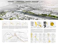
With an architectural practice commitment and according to the existing context, the proposed plan tries to take advantage of the opportunities and act critically on its threats; instead of emphasizing the comprehensive preservation of the context. Therefore, instead of making inclusive master plans of the mass - void of the whole area (with an approximate radius of 1 km), the context inflection points have regenerated as distinct projects. 4 effective and intervening focal zones were identified according to the analyses summary; all of these zones represent a waste region. A zone that has lost its prior quality or efficiency and its current state seems harmful. The only waste spaces strength is not claiming of private legal and organizations to separate them from the public city sector.
The design attitude is to enter into a critical dialogue between the site and the context separately in designing or losing (depending on the status quo). In other words, the proposed design adds words to the urban context, emphasizes the valuable sections, rejects its threatening sections, and generates a new context for enforcing the next zone idea. In responding the qualitative components of the public fields, this model covers the following:
- Horizontal and non-hierarchical communication of plan sections.
- The field is a human communication network and is against the traditional concept.
- Eliminating fixed and dictated functionality programs to the zones, like linear paths and centralized regions separation of reciprocating, and the making an intermediate and flexible nature.
- Not only interference with the public sidewalks (consumption-based) but also suitable access to all commercial orients.
- Sight strengthening to the square and historical elements.
- A semantic connection between old and new contexts.
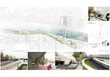
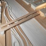
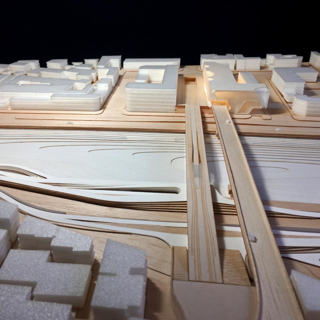
Four projects are designed in four different scales and typologies, which are: Landscape design of the Roga River, architectural intervention on the old bridge restoration and turn it into a pedestrian path, a multi-functional building, and the square central monument.
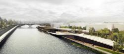
Project 1 (Roga Waterfront):
The river border with a natural bed was allocated to a linear park in the city master plan. This area has become a place of waste accumulation, because of roadway implementation without sidewalk in the current situation. This park was proposed to preserve the riparian zone, prevent the future widening of the existing carriageway, and suitable access for the permanent citizen’s presence. By restoration of this wasteland, the sidewalk is being connected to the new weekly market on the other riverside. Some of this project goals are face-to-face and visual facing to the river damages and unauthorized intrusion of the traditional market units, creating the future context to remove or redesign this region, restoration of water transport across the river between the market and sidewalks by non-motorized and eco-boats (as a collective recollection of market accessing) and creating a pedestrian between the market and Navvab Street to connect the historical and developing region of the city centre. They connect the street level and the old bridge for handicapped people by ramps with optimal intangible slope.
Project 2 (The Bridge Revitalization):
Since the new bridge was constructed to remove the traffic load from the old bridge, a few meters from the new bridge, the old one seems redundant; although it is the most important access to the central square. As the construction is contemporary with the "Ghazian" bridge and also typologically similar to that, this bridge is peripheral. The height is also about 4.5 meters and no direct access to the waterfront. This background reveals the minimal intervention idea in the structure of the bascule span (it was never used in its 80-year history). Unlike the four other spans made of integrated concrete, this span has a metal and independent structure. It is exactly located above the linear park on the riverside. This structure has been intervened in the present plan. Vertical access is predicted that include ramps and escalators to connect the linear park to the bridge surface. By doing so, the other side of the linear park is connected to the square.
Project 3 (The Social Condenser)
This project was proposed for land with a special commercial use in the comprehensive urban plan. But the unprofessional construction changed the entire area into the bridge car access. This conversion destructed a part of the historic wall of the main path to the square access.
From the the introduction of the “Social Condenser” by the constructivists until now, this concept has been used with different approaches and interpretations in architecture. It is included the social housing to the mixed-use projects and public cultural buildings. But the common spots of all projects with this idea were to condense the people’s presence to create communication and collective interactions (From programmed to random interactions).
According to the same general idea, but about its context, the project concept was also proposed in the central square regeneration plan of the public and peripheral spaces. The first difference between this project and the main references is that not intending to create a self- condenses; but, the purpose is to condense the pedestrian in the adjacent square and the peripheral public area, also facilitating and eliminating the traffic load, and utilizing the old bridge as a pedestrian path. The project situated on the carriageway and along the new bridge is both functional and symbolic. In other words, this building is an anti-machine machine. According to the quality of the adjacent public area to the same level, the floors are allocated to different operations:
1. The ground floor level has a car ramp and vertical access to the building which distributes the passenger traffic before entering the square (To strengthen the pedestrian path in the square field). Some of this traffic is immediately directed to the below street (Mirza Kuchak Khan Street) by the ramp.
2. The public parking lot entrance is located on the underground floor (the level of Mirza Kuchak Khan Street), exactly where the traffic is directed to this street; to facilitate the cars stopping and utilizing the pedestrian capacity. The rest of the floor is dedicated to the commercial passage for shifting the retail units of the river (current status) and the below floors are also parking lots.
3. The first and second floors are integrated structures with an open plan which reconstructs the city wall of the old bridge to the square from the outside (which turned into a plaza in this plan). It includes a central service core and continuous spaces from the inside with general and flexible usages. The structure will be open ideally and could be used for social, cultural, and artistic events. This part is proposed as a cultural-recreational complex in the second priority corresponding the comprehensive plan.
Project 4 (Central Square Monument):
This monument is the smallest project in the complex. It was previously presented for the only historical square area of the intervening zone called “central refuge” by our studio. This monument is located along the axis and the transitional line of the bridge (in the foreground) and the clock tower (in the background) of the square. Concerning the other three projects, it increases the semantic connection of the vast contemporary and the enclosed historical squares.
2015
Project 1/3: Roga Waterfront (Landscape Architecture)
Project 2/3: The Old Bridge Revitalization (Infrastructure)
Project 3/3: The Social Condenser (Mixed-Use Building)
--
Area: ~85000 sqm
Location: Gilan Province, IRAN.
Design Year: 2014-2015
Status: Design Proposal
Pratic Studio; Farzan Shamasblou.