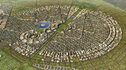
To the north west of Harare, along the Old Mazowe road the boundaries of the New City have been defined, bounding an area of 11.43 square kilometres. As a driver of change the New City design’s main goals are set to be achieved through the planning and designs of the New City are as follows;
• Create new opportunities for urban expansion and development;
• Facilitate a business destination that attracts external and internal investors.
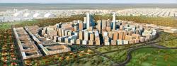
• Plan an intelligent, versatile, environment friendly city which will provide contemporary facilities for government, public, commercial, industrial, institutional, hospitality, residential,
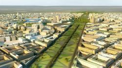
• The emphasis to be given to the environmental awarness through the open spaces, wide boulevards, large areas dedicated to parks and greenery.
• The relocation of the New Parliament Building, onto the slopes of the Mt. Hampden that assumes the pivotal role in the town planning design and development.
Inspired and motivated by Great Zimbabwe, the Master Plan bears the spirit of traditional planning through a contemporary interpretation. The urban planning stemmed from the position of the New Parliament Building, and a long highway linking it to the main roads. A network of circular nuclei is set along major traffic lanes and parts of the city, thus providing sub-centres. These circular centres are designed to dominate the rest of the city by higher buildings and therefore create urban nodes. They are set along major axis leading from New Parliament Building to major connection with Harare, Bindura Highway and other circles on Southern and Eastern segments of the city. Urban blocks surrounding these circles are proposed to be with medium densities containing buildings of 3 to 5 stories, housing retail in ground floors and residential or office spaces above. As town planners, we proposed low density residential zones all along the boundaries of the new city.
The major axis leading from New Parliament Building to the Independence Circle features green areas, water ponds and features, memorial buildings and monuments. On both sides of Constitution Highway, the urban design located the Government enclave with offices, national and other cultural institutions.
The town planner concept proposed a few blocks dedicated use, such as media centre IT centre, arts and crafts village, golf course and estate, cemetery etc. Regional shopping centre, large convention centre, show grounds and regional amusement park are located at suitable, easily accessed blocks. Neighbourhood centres, schools, religious buildings are located at suitable locations to provide suitable coverage of the catchment areas. The city design envisaged sites for bus terminals and metro stations throughout.
The brief instructed us, as town planners, to accommodate facilities related to the national mineral resources and will feature museums, diamond and other mineral auction centres, bank headquarters, National Stock Exchange and other related projects in the Diamond Circle. Due to the configuration of the terrain, on the Eastern part of the New City a large lake will be built. Part of banks of the new lake will be used for resort hotel and as well as luxury housing units, recreation area for the entire city while the rest of undulated land is planned to be extra low density. Finally on the south side of the New City will be the Agricultural area centred around a number of special industry sites and the Agricultural Showgrounds. The sewage treatment ponds are located at North and South-west ends of the city, while solar powered plant is proposed adjacent to North Sewage treatment plant.
The town planning design proposes a cohesive whole for the new urban development mixing all the realities of a whole new city and its major services.
2013
0000
Area: 1100ha
Usage: Town planning
Town planners: Pantic Architects