Submitted by WA Contents
Palestine | Cartographic Representation Of The Bombings’ “Atmospheric” Impact in Gaza
United Kingdom Architecture News - Aug 15, 2014 - 19:15 2968 views
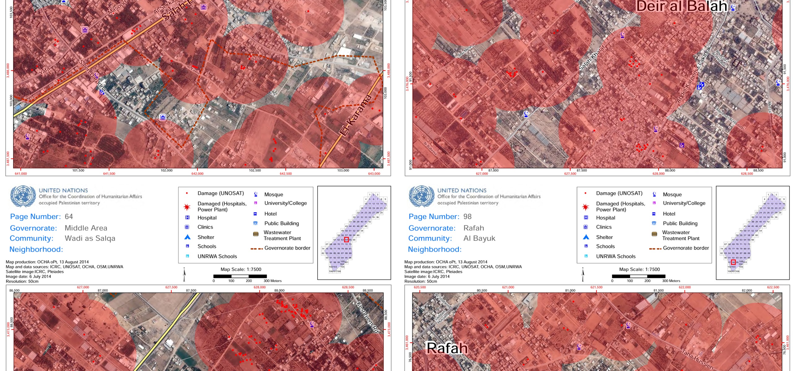
Maps of Gaza by the UN Office for Coordination of Human Affairs (August 2014) – Selected and Augmented with 200-meter radius circles for The Funambulist (August 15, 2014) Download a high-resolution version of the map here (9MB) (license: Creative Commons Attribution-NonCommerical-ShareAlike 4.0)
When it comes to the Israeli enforced organization of space in the West Bank and Gaza, one can always turns towards the UN Office for Coordination of Human Affairs in the Occupied Palestinian territories and the regularly updated maps they provide coupled with a multitude of important data. OCHA just released a 120-page “Gaza Crisis Atlas” that superimposes recent satellite photographs of the Gaza strip and their analyses in terms of damage imposed by the Israeli army bombing/shelling of this last month. Each red dot on these documents represents a destroyed structure, and it does not take much time to realize the amplitude of the bombings’ impact on the ground as red dots populate each page of the ‘atlas.’ What the precision of OCHA’s mapping fails to represent however, is the fact that a bombing is not confined to the violent physical destruction of a localized building, it also corresponds to an atmospheric volume of impact that I will try to expose in this article. In order to visualize this ‘atmospheric’ impact, I selected four pages of the OCHA ‘atlas’ and augmented each ‘red dot’ with a 200-meter radius circular red area. What this means is that everyone who lives inside one of these red areas has been experiencing at least one (often more) bombing in her/his immediate proximity — we can probably all agree that 200 meters equals immediate proximity when it comes to war. These four maps were selected for their representative characteristics in that some areas of the Gaza strip have been so heavily and systematically bombed that their maps would have been fully red, while a few other areas were more sporadically bombed, in particular in the less densely populated zones where the former Israeli settlements were situated. One of the map is in the North of Gaza, two others in the middle area, and the last one is near Rafah in the South, in order to illustrate how the totality of the Gaza strip was heavily affected.
The first aspect of the atmospheric impact that the Israeli army bombing has been having is the most immediate one: sound. The sound of bombs is haunting as it materializes a stop in time, a wait from which, one always realizes much too late that a bomb will explode nearby. For a month, the sound of bombs falling and exploding have been Gaza inhabitant’s daily sonic landscape. A few of them have recorded the sound of the bombs falling at various distances from their house. One, recorded by Farah Basil Baker is particularly poignant. If, like mine, your heart skips a beat when listening to it, we can begin to imagine without ever fathoming the continuous horror that this last month have been for Gaza inhabitants....Continue Reading
> via The Funambulist