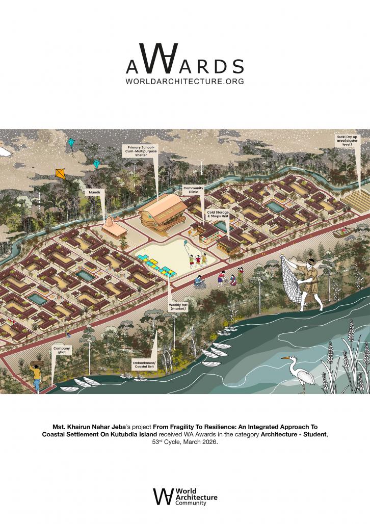
From Fragility to Resilience: An Integrated Approach to Coastal Settlement on Kutubdia Island
Nearly 40% of the global population lives within 100 kilometers of a coastline—regions rich in livelihood yet highly vulnerable to climate risk. Bangladesh, a low-lying deltaic nation along the Bay of Bengal, remains one of the most disaster-prone countries in the world. Cyclones, storm surges, sea-level rise, and erosion continuously threaten its coastal settlements.
Kutubdia Island, located in Ward 6 of Ali Akbar Dail Union, Cox’s Bazar, stands at the frontline of this crisis. Fishing, boat crafting, net weaving, and dry fish (sutki) processing define both the economy and spatial identity of the community. However, repeated disasters have left fragile, polythene-based houses destroyed, livelihoods disrupted, and families trapped in cycles of vulnerability and rebuilding.
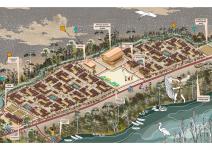
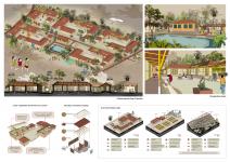
The project proposes a climate-resilient coastal settlement model that integrates ecological protection, social cohesion, and economic sustainability. Rather than replacing isolated houses, the design restructures the settlement across three interconnected scales: settlement, cluster, and homestead.
- At the settlement level, a defined Safe Zone is developed on a 12-foot raised mound (killa) to reduce flood and tidal surge impact. Mangrove belts function as natural storm buffers, while a protective canal system improves drainage and helps deflect wind forces during cyclones. Raised circulation networks ensure mobility during monsoon flooding, and spatial zoning reorganizes residential areas into safer territories while maintaining access to fishing grounds. A central Puja Mela Chattar acts as the social and cultural heart of the community, supporting festivals, gatherings, and collective decision-making.
- At the cluster level, scattered dwellings are reorganized into structured groupings that enhance shared open spaces, mutual safety, and efficient land use. Two designated sutki drying zones organize livelihood activities hygienically and systematically.
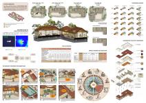
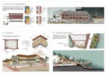
- At the homestead level, four housing typologies respond to existing social structures: compact single-family units, extended-family homes, joint-family units, and co-living houses. Each dwelling incorporates raised plinths, improved structural systems, and modular service cores, allowing affordability, durability, and incremental expansion.
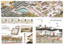
To further strengthen livelihood resilience, the project establishes the embankment as a structured sutki processing zone and introduces a three-level sutki production system integrated across homestead, cluster, and settlement scales. By activating the embankment as both protective infrastructure and economic spine, flood defense and livelihood generation are strategically merged.
A three-storied Primary School–Cum–Cyclone Shelter, engineered to withstand extreme wind speeds and tidal surges, provides refuge for approximately 1,300 people during disasters. In everyday life, it functions as a school and community hub—embedding resilience into daily activity. Supporting infrastructure—including fish collection and cold storage facilities, a weekly haat, boat repair workshops, a community clinic, and a new mandir—reinforces economic stability, healthcare access, and cultural continuity.
Through nature-based solutions, resilient housing strategies, structured livelihood zones, and participatory planning, the project transforms vulnerability into opportunity. It envisions Kutubdia not as a fragile coastline, but as a model of dignified, adaptive, and community-driven resilience—where protection, productivity, and social cohesion operate as one integrated system.
2025
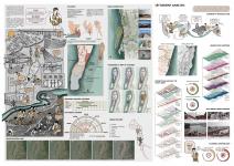
Project Site Location: Ward 6, Ali Akbar Dail Union, Kutubdia Upazila, Cox’s Bazar District, Bangladesh
Geographic Context: Coastal island settlement along the Bay of Bengal
Project Coordinates on Google Maps: 21.786606307891656, 91.86277047080266
Land Ownership: Bangladesh Forest Department
Total Site Area: 15.26 Acres
Project Scope: Integrated coastal settlement design addressing disaster resilience, livelihood strengthening, and community infrastructure at settlement scale, cluster scale, homesteadscale.
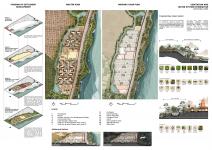
Master Planning Strategies:
a. 12 ft Raised Safe Zone (Killa Mound)
b. Mangrove Buffer Belt (Nature-based storm protection)
c. Defensive Canal System (Drainage wind mitigation)
d. Raised Circulation Network
e. Protective Zoning (Residential & Livelihood Segregation)
f. Embankment Activated as Sutki Processing Corridor
Residential Program:
Housing Typologies:
1. Single Family Unit – Type 1 (2 Sleeping Rooms)
2. Single Family Unit – Type 2 (3 Sleeping Rooms)
3. Joint Family Unit (4 Sleeping Rooms)
4. Co-Living Unit (Shared Service Core)
Common Features:
• Raised Plinth Construction
• Cyclone-Resilient Structural System
• Modular Sanitation & Service Core
• Provision for Incremental Expansion
Livelihood Infrastructure:
Three-Level Sutki Processing System:
• Homestead: Courtyard drying for small/low-value fish – Yield ~12%
• Cluster: Raised bamboo racks with sorting/grading – Medium-value sutki – Yield ~17%
• Settlement (Embankment Zone): Large structured yard drying – Table-grade sutki – Yield ~22
Designer Name: Mst. Khairun Nahar Jeba
Studio mentors: Md. Muktadir Rahman, Rifat Bin Firoz
Supervisor: Samia Zabeen
Co-supervisor: Muntaha Marzan Shetu
From Fragility to Resilience: An Integrated Approach to Coastal Settlement on Kutubdia Island by Mst. Khairun Nahar Jeba in Bangladesh won the WA Award Cycle 53. Please find below the WA Award poster for this project.

Downloaded 0 times.
Mst. Khairun Nahar Jeba