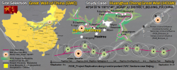
A symbol of China’s, the Great Wall (GWC) snakes through the countryside over deserts, hills and plains. The GWC was created under Qin Empire (221-206 BC), but most of the current wall dates from de Ming Dynasty (1368-1644), with approximately 6.400Km. Around 40% has disappeared, 20% has been restored and 40% is in poor condition, in approximately 2.450Km to apply RGB_Project
This proposal aims to generate the occasion and potential of the GWC as a main axis through the northern China, in the boundary with Inner Mongolia, a region that is important as a potential break for advancing desertification and climate change, to generate Green_Spots along this natural path in sustainable and replicable landscape structures to help stop desertification, revitalize the area and be an asset to the population: the N=MxRGB_Project.
RGB_Project aims to balance the equation between Man and Nature, in this case M/N?1, due to the contradiction of the strength of the wall. This element acts as a natural element which although built by man, became autonomous and prevents Man himself to settle down and stay in this landscape.
RGB_Project will transform this equation in a multisystem:
M/N?1›N=M×RGB›(N×1)=(M×RGB)›(M/N)=(1/RGB)›(M/N) = (1/1) › M/N=1
The Huanghua Cheng section is located in Huairou District, about 85 Km from Beijing, near Xi Shui Valley. It is 10 Km long and joins with Mutianyu Great Wall in the east, and Juyongguan Pass and Badaling in the west. The entire section of wall comprises of 6 forts, 6 passes, 12 beacon-towers, and 32 guard towers. Nearby there is the Jintang lake and a reservoir with crescent shaped. This section it is also known as the Great Wall under the Water, because three separate sections of the wall are submerged in the Xishuiyu Reservoir, build in 1974; consequently, some low-lying sections were inundated.
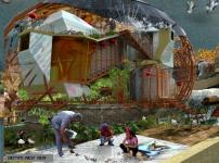
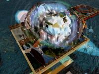
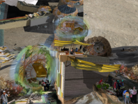
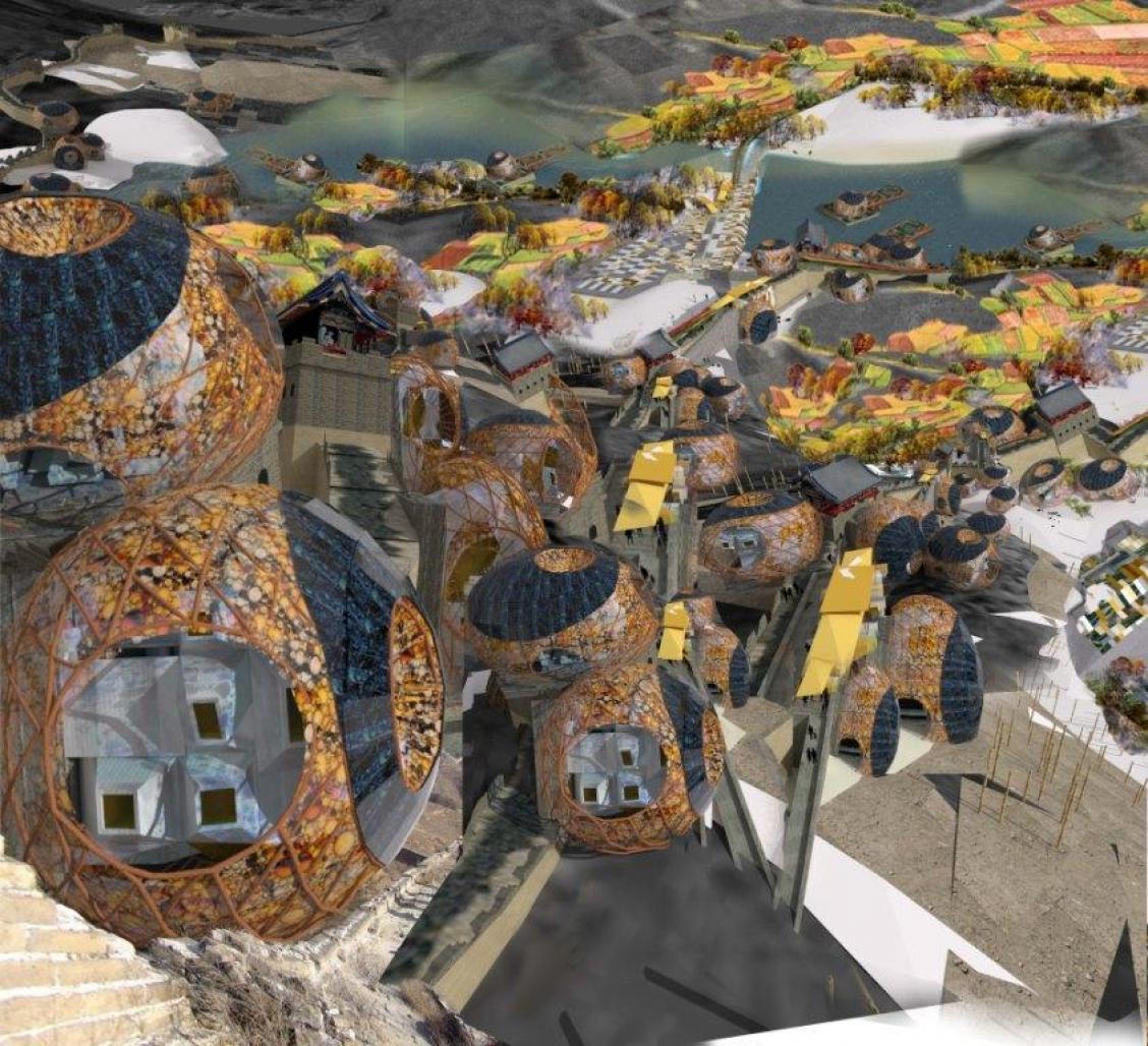
RGB_Project involves developing a Prototype Green_Spot#01 in the shores of little west lake and the Huanghua Cheng GW section in an extension of 10 Km, replicable in other sections of the GWC in to a linear border. It will be a production community; it aims at the idea of making the unemployed in to sustainable workers and sustainable families through producing their own food and foster a spirit of co-existence and community in perfect equilibrium with Nature.
By definition in this conceptual proposal, the Green_Spot it is a demonstrable case materialized into a Prototype according RGB_Project which goal is to change Nature in a joint effort to modify the imbalance in the equation M/N at the present point.
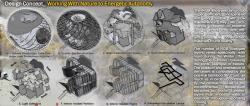
RGB_Project consists in:
one Community Center_a and a variable number of RGB_Biotypes_b.
After RGB_Project implementation Great Wall of China, in cooperation with Man and Nature, will be an efficient Buffer Zone either to desertification either to starving and lack of food supplies for Man and animals in North China.
Before RGB_Project implementation, the proposal site is 100% Nature, with Great Wall supremacy over the other biomes, such as Forest and Man. Study case Green Spot#01 applied to HCGW section provides a new Nature, made by agricultural fields created in and by RGB_Biotypes plus RGB_Community Center_a as a living support for Man. This change will be done without Forest lost for Man although it is needed to plant more native trees, such as Mongolian Scotch Pine, Chinese Pine, larix, spruce and willow, as well as shrub species like pea shrub and sea-buckthorn, restoring the ecosystem to health.
Study Case Green Spot#01 applied to HCGW section provides a new Nature, made by agricultural fields created in/by RGB_Biotypes with RGB_Community Center_a into a Ecovillage Community with an anti-desertification Reforestation Plan.
2012
This proposal intervention is in the territory of northern China, along the provincial border of Inner Mongolia, where will be created sustainable and replicable landscape structures named as Green_Spots which are buffer zones that will help to stop desertification process. This benefit is extended to major northern cities like Beijing and also southern cities of China, which are already feeling the advance of desertification. We focus our proposal in China and in this nature serious problem with negative consequences for humanity, because desertification is a problem that is changing the Earth’s ecosystems reaching all continents, with China being one of the most severely impacted countries.
Determining the factor to transform the actual equation M/N?1 into M/N=1 is the first step for achieving the ecosystem equilibrium. This factor will be achieved by establishing the necessary amount of physical layers that will realize the desired balance. As we can easily understand, it is Man the primary factor that we can actually change, and then Man equipped with the required tools will be able to change Nature, in a joint effort, to modify the imbalance in the equation at the present point.
The vegetable covering is a primary indicator of land desertification, and thus the contributions from each data layer will be differentiated: Green layer is ahead with a total application rate of 74%, subdivided into fisheries (11%), pastureland (13%), cropland (22%) and forestland (28%); the Red layer has a weight of 13%; and the Blue layer has the final 10%. After application of proposal, we intend to get as final data for the green layer, a uniform area of land not affected by desertification, with no significant patches of land wasted and with a cover of at least 50%.
As actual desertification process it is estimated that 233.098 hectares of land become desert each year - not because the climate is drying, but because the natural land cover has been destroyed. We estimate that each RGB’s Green_Spot creates at least 7.846 hectares of natural land cover, and therefore it will be needed to implement 30 units by year to counteract the annual desertification average with an amount of 235.380 hectares. The factor 0,1 (10%) applied to the hypothetical Great Wall total area disposal, leads to the hypothesis that if a buffer zone section with 30 RGB’s Green_Spots per year is implemented, until a maximum of 245 units in eight consecutive years, that would created almost 2 million hectares (1.922.270 hectares) of natural land cover which would help to delay desertification process significantly.
The sum of RGB_Project data and China’s reforestation Program is 1.411.842 hectares by year beginning 2012 and ending 2020 with a total amount in this period of more than 12 million hectares (12.706.578 hectares) and its implementation in a concerted effort would stop desertification in next 8 years and after that period would made desertification values go back, in progressive way, until reach 1973 values, in estimated more 20 years application by 2040.
mafalda carmona
Mafalda Carmona