Historically, and particularly in the case of Bogotá, urban development has taken as its design paradigm the human scale: our cities are designed based on temporality and human needs in terms of the use of their resources, their sustainability over time and their ecological impact. This paradigm leads to a simplistic conception of the scale of the city's impact on its environment; Bogotá's urban planning portrays an unawareness of the footprint left by the city both in space and time. It produces ruptures with consequences that will continue to be felt when the city's name has been erased from the history books. To understand this scale is to understand the true size of the city in time and space and how the impact of Bogotá extends far beyond the built area. Specifically, the hydrological, geological and phytological processes that have been shaped over millions of years have been disrupted and transformed by the relatively sudden appearance of the city. Taking into account these processes, but also the often irremediable impact they create, allows us to take the first steps to propose a new way of doing architecture and urbanism with a focus in building cities that relate in a larger scale in time and space in a more friendly, sustainable and equitable way with their environment. Therefore, this project is dedicated to solve the question of how to think architecture from a perspective that extends beyond the anthropological scale to transform a city that breaks with natural systems in a key piece in its functioning?
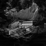
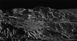
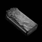
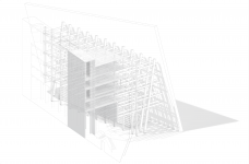
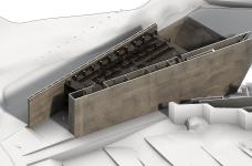
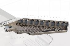
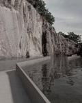
Given the scale of the problems caused by the indiscriminate development of Bogota, it would be beyond the reach of any project to solve them in its entirety. However, in response to these ruptures, this work proposes a buffering solution to the water, geological and phytological problems of Bogotá, designing a water collecting infrastructure that participates in the urban dynamics by taking advantage of the strategic location of the abandoned spaces left by the quarries distributed in the foothills of the mountain range along the urban perimeter on the border between the natural and the built. In these places the intervention is organized around three fields: Hydrology, Phytology and Geology. The first is proposed as a large urban infrastructure which is also ecological. It allows to alleviate the loads on the basins and moors while satisfying the population's access to water. The second hosts a space that functions as an ecosystemic regulator through the production and transformation of organic matter. This is, on one hand, the storage and germination of native seeds that are distributed to recompose the original vegetation landscape, and on the other hand, the collection and transformation of invasive species into construction material. And the last one, the premise is to magnify the geological cycles evidenced by the excavation of the quarry. Thus, incorporating the disturbance caused by the original excavation into a new landscape that reconciles the relationship between city and mountain range. It is not a question of denying and covering up a wound in the mountain, but of welcoming it as a beacon of memory and reconciliation with the territory.
2022
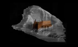
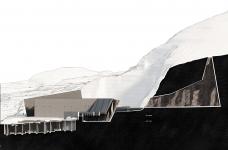
The project proposes a metropolitan infrastructure distributed on the vacant quarries along the skirts of the mountain. Only one of the quarries is design in detail to create the strategy on how the others should be intervened. The quarry selected is located in the neighbourhood “las Delicias del Carmen” which is on the threshold between the city and nature.
DESIGN: Emma Bonilla Albornoz
TUTORS: Claudio Rossi & Daniela Atencio
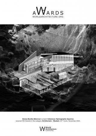
Inherence: Hydrographic Quarries by Emma Bonilla Albornoz in Colombia won the WA Award Cycle 42. Please find below the WA Award poster for this project.
Downloaded 0 times.

Emma Bonilla Albornoz