The aim of this project is to present the new “12th district proposal as a model for upgrading the other downgrading settlements” in inner city. Site plan of 12th district proposed three storey houses in Sarayiçi / Edirne. This report was prepared in relation to resolution about settlement of sustainable development in conditions of crisis over total environmental resources in Turkey, and represents also part of my research project to determine the present situation as it exists in Edirne {Erdogan, 2006}. The aim of the research is to upgrade the derelict housing areas of the border city of Edirne. As is mentioned in the abstract, the city has been one of the most significant commercial and education centers throughout history.
Rational for the project
The administrative and geographical division of Turkey, its regions, districts and sub-parts are well-defined {Sanli et al, 1976}.In accordance with planned development strategy, Turkey as a whole is divided into eight regions and 19 sub-regions of which Thrace is one of such sub-region.
Edirne is city in the West Marmara region of Thrace. The greater Marmara region of Turkey includes the coastal parts of western Anatolia along the Sea of Marmara and the part of Turkey that lies on the European mainland. This area lies between the Black Sea and Aegean Sea with the Mediterranean coastal climate prevailing over most of the area. Thrace, however, though part of the Marmara region, has a more severe climate.
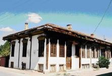
The city of Edirne consists of 11 districts and 24 neighborhoods. The districts are divided into three
Groups. The group comprises the historic outer the districts of the city proper, {Karaagaç, Yildirim, Yeniimaret}; the second group includes the central district of the inner core {Kaleiçi, Çavusbey, Sabuni, Taslik, Kiyik, Aysekadin} and the third group includes the new settlement districts in the city proper {Istasyon, Hacilarezani}.
Development of the Yeniimaret Region
The city represents the basis of sustainable development of society. As a consequence, the physical and social conditions of the central districts {2nd group} and the historical outer districts the inner city proper {1st group} were investigated within this research project. The new settlement districts of the city proper {3rd group} lie the east o the city, and these new settlements are moving out the districts involved in farming pursuits.
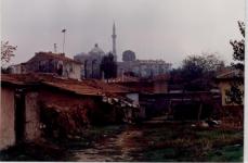
With regard to the surveys conducted during the research, Yeniimaret, the region in which Sarayiçi district is located, is geographically isolated from the central district of the city proper by the Tunca River. That river flows around the northeast part of this district with large areas lying between that part and the city centre.
During the Ottoman age the lands here consisted of green fields and resting pavilions that belonged to the local palace elite. These buildings and pavilions built for entertainment and retreat were destroyed during the later battles that were fought here. Today, traditional Turkish wrestling contests and festivals are held in this area.
According o surveys and map studies conducted as part of this research, at times during its long history the Tunca, Meriç and Arda rivers, flowing between the city centre and the historical outer districts, were used for various purposed such as irrigation, hunting, transportation etc. During the Ottoman period the river edges were fortified by steep and high banks. Because the palaces, the kiosks and the gardens of the rich were located in this area, the Ottoman used this kind of embankment to protect the land from floods. Today, however, the riverbanks are no longer fortified, resulting in flooding and damage to the agricultural fields and housing settlements lying nearby. To forestall this kind of damage the rivers in the city {Meriç, Tunca} again need to be controlled and steps need to be taken as soon as possible to beautify and restore the areas of Sarayiçi, transforming it int
2006
nevnihal erdoğan

.jpg)