With the Eco-nect project, we aimed to create a multifunctional public space in the city in terms of Environmental, Economic and Social aspects and to increase the attractiveness of the region by using the strong product potential of the Basmane - Ödemiş train line, which has lost its importance today, in a SUSTAINABLE manner. As general the user profiles are expected to be; travellers, researchers, vendors, students and locals.
In Izmir there is a strong potential on the Ödemiş Basmane railway line. We wanted to take the potential of agriculture in Ödemiş and flowers in Bayındır and create spaces for their exhibition, sale and research in Basmane so Basmane and the trainline would gain importance as an agro-cultural centre. In addition to this, as also is a high renewable energy potential on this line such as; biogas, solar and geothermal energy the site would be mostly using renewal energy generated on the site and on these districts. In addition, the organic waste generated on the site will be taken to Ödemiş to generate more biogas energy and used as fertilizer. Also, the commercial situation of Basmane will change. Currently, there are only types of shops that are visited momentarily and in specific times. So, near the Basmane train station the commercial areas are going to be mixed use and surrounded of cultural activities to create a continuous circulation and revive Basmane as a social node. This circulation will be supported with sustainable transport modes such as bicycles and green public transportation and only pedestrian paths.
As we mentioned previously, there is a strong potential on the Ödemiş Basmane railway line in the agriculture, floral and energy sectors. Most of the agricultural products of Izmir are mostly grown in Ödemiş, Bayındır, Torbalı and Menderes such as; Potato, Leek, Cauliflower and Eggplant. Also, Gaziemir and Menderes are to important districts for geothermal energy and Ödemiş district with the biogas energy.
One of the first things we analysed was the services provided between a 15 min range. There are 5 private hospitals and 2 public hospitals. Unfortunately, these public hospitals are only for paediatric and dental care, so for other services there is a need to go to another area. As for education, all the levels of education are provided between the range of 15 minutes. There are also many urban attractions such as, St. Vukolos church, Agora, Kemeraltı Historical Bazaar etc. in the range of 20 minutes by walking. It has also been observed that there are very few places to go by bicycle in the area.
As a result, we have created a synthesis that will enable us to evaluate the study field and select proper micro study field under many headings and follow the path in the development of our project.
To briefly talk about the synthesis; the fact that rainwater is currently harvesting and discharged into the sea, the sea is polluted due to waste, some parts of the area are at flood risk due to lack of adequate infrastructure, there are many buildings in the area that have completed their economic life, and the southern parts of the area have an intense urban heat island effect have been evaluated as negative. However, the fact that Kültürpark and Kordon create a cold island effect for the area, the presence of many cultural buildings in the area, the presence of a dense flow of people on the east-west axis, the fact that Basmane Square is a node for public transportation lines, and the public uses that cannot adequately handle the use of the area are defined as potential for us.
As a result, of all the analyses a concept map was determined. The main goal is to transform Basmane into the commercial, social and transport node as it showed that has the potential. The land use of the site would be transformed into “mixed use” buildings with commercial, cultural and accommodation services, so it will generate a constant circulation of people and revive the train station. All the structural modifications of the area are designed for a sustainable future. So, the all the modified roads would incorporate permeable materials to absorb the rainwater to reduce the floods risks, all the transport systems will be electrical ones and their stops will produce solar energy and all the construction materials will be designed to be recyclable. In addition, the agglomeration of public transport stops would be determined and supported with a Park&Ride stop so, it also would reduce the private car dependency through the site. In addition, the roads would be redesigned to prioritize the pedestrian and bicycle users and reduce the private car amount, while the parking lots would be reduced from 63.247 m2 to 15.000 m2 of a multi-story parking lot and the ones on the Kültürpark and Konak Pier.
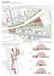
As our main working area, we chose the surroundings of the railway that stans between Basmane Station and the highway. This area has the potential of being a public transport node welcoming numerous citizens. However, most of the buildings are not being used or are in a really bad condition. As our concept we suggest, to reuse the registered buildings for cultural and commercial activities by restoring them, increasing the “mixed use” culture into the empty and other buildings of the area and to revive the commercial potential of the area. For this, we aim to use the products brought from Ödemiş and Bayındır as mentioned before. Firstly, by selling them in the Auction area and secondly creating a collaboration with the research area and its urban farming facilities. We expect that this research labs affects the Kavram university and increase its relevance by incrementing the types of degrees and number of students. Thats why the old police school area will be redesigned to become a public dormitory. To force the users to reduce their car independency the area will supported by pedestrian spine and bicycle routes and there won’t be any parking facilities inside the area except the one exclusive for the auction facilities.
The most important point of our project is to design the surroundings of the train station under ecological and sustainable strategies. We defined our working method under five dimensions,
Land Use and Urban Design
Energy Efficiency
Water Efficiency
Transportation Efficiency
Material and Resource Consumption
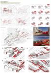
With the implementations under the “Land Use and Urban Design” dimension we expect 4 changes. Firstly, establishing a green hierarchy that cooperates with the “Kültürpark” that will fight the high heat island effects of the area and that will increase the permeable surfaces. Also, changing the traffic-oriented streets to pedestrian focused by increasing the ratio of trees in the pavements. Secondly, changing all the impermeable materials off the area to permeable ones to collect the rainwater and reduce the floods of the area. Thirdly, transforming the area in a more accessible one by promoting the pedestrian and bicycle routes in the area while connecting all the public transport stops and the important locations. Lastly, about 5.000 m2 of the area is going to be used for urban farming purposes to improve local microclimate conditions, boost urban waste recycling and support biodiversity in cities.
With the strategies under the “Energy Efficiency” dimension we expect to transform the area to “energy neutral”. The area will use the renewable energy provided from the solar panels within the site and from the energy facilities of the districts on the Basmane-Ödemiş railway. Ödemiş will produce energy from the organic waste of the area and distribute it to the green train and the energy needs of the site. The buildings will also follow some design decisions to reduce the energy consumption and to produce renewable energy. Also, the infrastructure will be changed to increase the efficiency. Like cooling systems that use the sea water, green transportation systems and smart lighting approaches.
As for the “Water Efficiency” there are two main water sources that is going to be use in our site: grey water and rainwater. The rainwater will be harvested by the buildings, the green permeable streets and the landscape. This water will be used for the buildings’ water necessities. The grey water produced by these buildings will be filtered in the site and used as irrigation water for the green areas and urban farming.
As we mention before one of the aims of this project is to increase the accessibility of the area. There are three strategies under the “Transportation Efficiency” dimension to achieve this. The first one is to create walkable streets that connects the important facilities of the site. Secondly, promote the use of bicycles in the area by creating paths and stops for them. Thirdly, eliminating the excessive parking lots and limit them to Park&Ride parking lots near the public transportation stops.
Lastly, under the “Material and Resource Consumption” dimension we developed our strategies according to the circular economy system. All the waste of the area will be reused as much as possible. Firstly, the empty buildings will be provided with new purposes. Secondly, the structure’ materials of demolished buildings will be recycled to be use in other constructions. Finally, the organic waste materials of the area will be used as fertilizer for the urban farming facilities or to generate renewable energy and the grey water will be used for irrigation purposes.
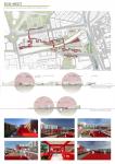
The general design ideas were defined to create a more social and sustainable area. Most of the roads were change to pedestrian only paths to provide a safer experience for the users. New cycling routes were also proposed in line with sustainability strategies. This expansion means more travel choices than ever, provide a variety of alternatives for everyone's journey. The buildings heights were thought to create a valley which came close to the human scale on the social areas. A new 3D circulation was stablished with overpasses integrated with the buildings designs so the people could enjoy the area without being interrupted by the railways and traffic. This overpasses also are thought to provide covered areas that provide shadow on the ground circulation. For this to occur, 149.064 m2 of the area will be change. In line with all these strategies, the area is coming to life with the active facades in the area were increased with the proposed structures. It is providing a delightful and interactive experience for everyone. The site’s total constructed area will occupy the 27%, the roads and the railway the 39% and the green areas the 30%. In addition, we add a 13% of piazza usage to the site. As for the green areas more than a half is still formed by the Kültürpark, the passive green areas now are formed by the railway buffer with a 21%, with our additions the 13% of the open spaces is now active green spaces and now the 6 % of the open areas is used as urban farming.
Through the Eco-nect project, our objective was to establish a versatile public space within the city, focusing on environmental, economic, and social aspects. We aimed to enhance the appeal of the Basmane - Ödemiş train line, currently less significant, by leveraging its robust product potential in a sustainable manner. Our aim was to harness the agricultural potential of Ödemiş and the floral richness of Bayındır, creating spaces in Basmane for the exhibition, sale, and research of these products. This approach sought to transform Basmane and the train line into a significant agro-cultural center. Moreover, this initiative aimed to also impact the landscape of Basmane by making it surrounded by cultural activities, fostering continuous circulation and revitalizing it as a social hub. All these projects are being supported by sustainable and circular systems that transform Basmane into a more eco-friendly environment.
2023
İzmir Basmane district is one of the most important node points of İzmir in terms of accessibility. It connects rural districts to the center with the train line and urban areas with public transportation.
The increase in run-down areas in and around the station, inadequate physical connections between services, lack of a pedestrian-oriented design, scarcity of open spaces, unpreparedness for climate changes reduce the use of the area.
When the current situation is examined, it is seen how far behind the area is in the development of sustainability, with low renewable energy production, high energy consumption, lack of utilization of water resources, lack of emphasis on waste management, and excessive use of cars.
With the Eco-nect project, it was aimed to increase the attraction power of the region by creating a multifunctional public space in the city in terms of Environmental, Economic and Social aspects by using the strong raw material potential of the Basmane - Ödemiş train line, which has lost its importance today, in a SUSTAINABLE way. In line with this goal, spaces were designed to serve the marketing, research and exhibition of products.
Supervisor (or Instructor): İpek Akpınar Aksugür
Designers: Tahir Baran Özdemir, Güliz Lise, Meryem Dişci, Beyza Pekdoğan, Micaela Saray Gagliardo, Gizem Engindeniz, Sevda Arslan, Fatma Yudum Uluer


